Showing posts with label earthquake. Show all posts

Thursday 12 February 2015

Something had to give - Baffin Island hit by M4.6 earthquake

An earthquake with a magnitude of 4.6 on the Richter scale hit Baffin Island on February 12, 2015, at 02:11:40 (UTC). The image below, from the United States Geological Survey (USGS), shows the epicenter of the quake.


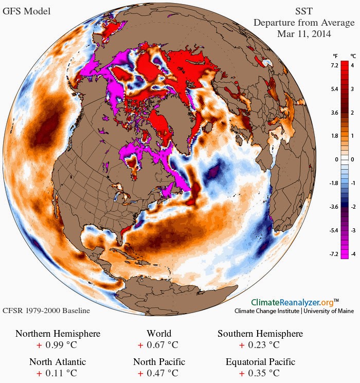
The earthquake occurred at a time when surface temperature anomalies over parts of North America and Greenland are at the bottom end of the scale, while surface temperature anomalies over parts of Siberia are at the top end of the scale, as illustrated by the image below.


The image below shows pressure differences reaching the top and bottom ends of the scale (left). At the same time, sea surface temperature anomalies around North America and Greenland are at the top end of the scale (right). It appears that something had to give. 


This earthquake is important, given that it hit an area without large faultlines (though earthquakes are common here, also see this discussion). The Baffin Island earthquake occurred in an area prone to glacial isostatic adjustment, as illustrated by the image below.

From "http://grace.jpl.nasa.gov", (unfiltered version). Credit: A, G., J. Wahr, and S. Zhong (2013) "Computations
of the viscoelastic response of a 3-D compressible Earth to surface loading: an application to Glacial Isostatic
Adjustment in Antarctica and Canada", Geophys. J. Int., 192, 557–572, doi: 10.1093/gji/ggs030
Glacial isostatic adjustment as a phenomenon takes place over relatively long periods. An additional problem is extreme weather events influencing the occurence of earthquakes more immediately.

Here's an update on the situation. Five earthquakes occured on February 13, 2015, close together, including a magnitude 7.1 at the Northern Mid-Atlantic Ridge, south of Greenland:
- M5.3 Northern Mid-Atlantic Ridge 2015-02-13 18:48:16 UTC 10.0 km
- M4.9 Northern Mid-Atlantic Ridge 2015-02-13 18:58:06 UTC 10.0 km
- M7.1 Northern Mid-Atlantic Ridge 2015-02-13 18:59:12 UTC 13.8 km
- M4.7 Reykjanes Ridge 2015-02-13 21:25:18 UTC 10.0 km
- M5.2 Reykjanes Ridge 2015-02-13 19:33:10 UTC 14.2 km

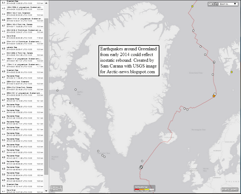
This M7.1 is the largest earthquake to hit the area around Greenland in a decade or more. And it's not just this one that has recently hit the area. The image below shows the recent Baffin Island quake in yellow, and the earthquakes that occurred today at the Northern Mid-Atlantic Ridge in orange. Furthermore, there are recent quakes on Iceland in orange and yellow. There were also three large earthquakes in the Greenland Sea, the 4.6 one is highlighted in blue (otherwise it would have been hidden).


The image below gives an impression of extreme weather events on February 13-14, 2015. 


Boston has meanwhile run out of room to dump snow, while roofs have collapsed in Massachusetts under the weight of the snow. Lnks between extreme weather events and earthquakes have been discussed before. Extreme weather events look set to intensify as temperatures in the Arctic keep rising. This is very worrying, given the vulnerability of methane under the seafloor of the Arctic Ocean. Furthermore, there are also indications that methane could be released from Greenland due to sequences of strong compaction and expansion of the snow and ice cover, due to extreme weather events. 

High methane levels have recently been recorded in the atmosphere over the Arctic Ocean, including over Baffin Bay.


Methane is present in sediments under the Arctic Ocean in the form of free gas and hydrates. Earthquakes can send out strong tremors through the sediment and shockwaves through the water, which can trigger further earthquakes, landslides and destabilization of methane hydrates.

As temperatures in the Arctic keep rising, the jet streams and polar vortex are changing their shape, in particular becoming more wavy, which can cause more extreme weather events such as the events described above.

The situation is dire and calls for comprehensive and effective action, as discussed at the Climate Plan blog


Saturday 26 April 2014

M5.1 Earthquake hits Greenland Sea

An earthquake with a magnitude of 5.1 on the Richter scale hit the Greenland Sea on April 26, 2014, at 03:55:33 UTC at a depth of 10.00 km (6.21 mi). The epicenter of the earthquake is located right on the faultline that crosses the Arctic Ocean, at 73.479°N 7.974°E, some 567km (352mi) SSW of Longyearbyen, Svalbard.

[ click on image to enlarge ]
This follows four further recent earthquakes close to Svalbard or on the faultline north of Greenland, as indicated on above map. All these earthquakes struck at a depth of 10.00 km (6.21 mi).

Some of these earthquakes have also been discussed in earlier posts:
M4.6 - North of Franz Josef Land, 2014-04-13 02:12:19 UTC, also discussed in this post
M4.2 - North of Franz Josef Land, 2014-04-04 07:01:30 UTC
M4.4 - 262km NE of Nord, Greenland, 2014-04-22 10:30:23 UTC, also discussed in this post
M4.3 - 148km SSE of Longyearbyen, Svalbard, 2014-04-24 08:33:06 UTC
M5.1 - Greenland Sea, 2014-04-26 03:55:33 UTC
M4.5 - Gakkel Ridge, 2014-03-06 11:17.17.0 UTC, also discussed in this post

There have been a large number of earthquakes around Greenland since early 2014, as illustrated by the image below. This could be an indication of isostatic rebound, as also discussed in this earlier post.

[ click on image to enlarge ]

As melting of the Greenland Ice Sheet speeds up, isostatic rebound could cause earthquakes around Greenland to become stronger and occur more frequently. Earthquakes in this region are very worrying, as they can destabilize hydrates contained in the sediment under the seafloor of the Arctic Ocean. Furthermore, one earthquake can trigger further earthquakes, especially at locations closeby on the same faultline.


Related

- M4.4 Earthquake hits Arctic Ocean north of Greenland

- M4.5 Earthquake hits Arctic Ocean
http://arctic-news.blogspot.com/2014/04/m45-earthquake-hits-arctic-ocean.html

- Earthquakes in the Arctic Ocean
http://arctic-news.blogspot.com/2014/04/earthquakes-in-the-arctic-ocean.html

- Methane, Faults and Sea Ice
http://arctic-news.blogspot.com/2013/11/methane-faults-and-sea-ice.html

- Norwegian Sea hit by 4.6M Earthquake
http://arctic-news.blogspot.com/2013/11/norwegian-sea-hit-by-46m-earthquake.html

- Greenland Sea hit by M5.3 Earthquake
http://arctic-news.blogspot.com/2013/10/greenland-sea-hit-by-m53-earthquake.html

- Earthquake hits waters off Japan
http://arctic-news.blogspot.com/2013/10/earthquake-hits-waters-off-japan.html

- Earthquake hits Laptev Sea
http://arctic-news.blogspot.com/2013/09/earthquake-hits-laptev-sea.html

- Methane Release caused by Earthquakes
http://arctic-news.blogspot.com/2013/09/methane-release-caused-by-earthquakes.html

- Earthquake M6.7 hits Sea of Okhotsk
http://methane-hydrates.blogspot.com/2013/10/earthquake-m67-hits-sea-of-okhotsk.html

- Sea of Okhotsk
http://methane-hydrates.blogspot.com/2013/06/sea-of-okhotsk.html

- Seismic activity
http://arctic-news.blogspot.com/p/seismic-activity.html

- Climate Plan
http://climateplan.blogspot.com


Monday 14 April 2014

M4.5 Earthquake hits Arctic Ocean

An earthquake with a magnitude of 4.5 on the Richter scale hit the Arctic Ocean on April 13, 2014, at 02:12:19 UTC at a depth of 10.00 km (6.21 mi).


The epicenter of the quake is located right on the faultline that crosses the Arctic Ocean, at 86.687°N 45.393°E, some 800 km north of Franz Josef Land.

Earthquakes at this location are very worrying, as they can destabilize hydrates contained in the sediment under the seafloor of the Arctic Ocean. Furthermore, one earthquake can trigger further earthquakes, especially at locations closeby on the same faultline.


Related

- Earthquakes in the Arctic Ocean
http://arctic-news.blogspot.com/2014/04/earthquakes-in-the-arctic-ocean.html

- Methane, Faults and Sea Ice
http://arctic-news.blogspot.com/2013/11/methane-faults-and-sea-ice.html

- Norwegian Sea hit by 4.6M Earthquake
http://arctic-news.blogspot.com/2013/11/norwegian-sea-hit-by-46m-earthquake.html

- Greenland Sea hit by M5.3 Earthquake
http://arctic-news.blogspot.com/2013/10/greenland-sea-hit-by-m53-earthquake.html

- Earthquake hits waters off Japan
http://arctic-news.blogspot.com/2013/10/earthquake-hits-waters-off-japan.html

- Earthquake hits Laptev Sea
http://arctic-news.blogspot.com/2013/09/earthquake-hits-laptev-sea.html

- Methane Release caused by Earthquakes
http://arctic-news.blogspot.com/2013/09/methane-release-caused-by-earthquakes.html

- Earthquake M6.7 hits Sea of Okhotsk
http://methane-hydrates.blogspot.com/2013/10/earthquake-m67-hits-sea-of-okhotsk.html

- Sea of Okhotsk
http://methane-hydrates.blogspot.com/2013/06/sea-of-okhotsk.html

- Seismic activity
http://arctic-news.blogspot.com/p/seismic-activity.html

- Climate Plan
http://climateplan.blogspot.com


Wednesday 12 March 2014

Has the descent begun?

On March 9, 2014, Arctic sea ice area was at a record low for the time of the year, at only 12.88731 square kilometers.


Sea ice extent shows a similar descent, as illustrated by the NSIDC image below.

NSIDC update: The image below shows that Arctic sea ice extent was 14.583 square kilometers on March 11, 2014 (light green line), a record low for this time of the year and smaller than it was in 2006 (magenta line) and 2011 (orange line) at this time of the year.


The situation is dire, given that methane concentrations have risen strongly following an earthquake that hit the Gakkel Ridge on March 6, 2014, as illustrated by the image below.

[ click on image to enlarge ]
Huge amounts of methane have been released from the seafloor of the Arctic Ocean over the past half year, and the resulting high methane concentrations over the Arctic will contribute to local temperature rises.

The image below shows that sea surface temperatures are anomalously high in the Arctic Ocean and off the east coast of North America, from where warm water is carried by the Gulf Stream into the Arctic Ocean.


The prospect of an El Niño event makes the situation even more dire. NOAA recently issued an El Niño Watch. This follows a conclusion by an international research team that found a 75% likelyhood of an El Niño event in late 2014.

The consequences of sea ice collapse would be devastating, as all the heat that previously went into transforming ice into water will be asbsorbed by even darker water, from where less sunlight will be reflected back into space. The danger is that further warming of the Arctic Ocean will trigger massive methane releases is unacceptable and calls for comprehensive and effective action as discussed at the Climate Plan blog.


Related

- M4.5 Earthquake hits Gakkel Ridge
http://arctic-news.blogspot.com/2014/03/m45-earthquake-hits-gakkel-ridge.html

- Climate Plan blog
http://climateplan.blogspot.com


Monday 10 March 2014

M4.5 Earthquake hits Gakkel Ridge


The above image shows recent large methane release over the Gakkel Ridge, the faultline that crosses the Arctic Ocean between the northern tip of Greenland and the Laptev Sea (red line on map). Methane readings were as high as 2395 ppb at 586 mb, an altitude that often shows high methane readings originating from the Arctic Ocean.

An earthquake with a magnitude of 4.5 hit the Gakkel Ridge at a depth of 2 km on March 6, 2014, at 11:17.17.0 UTC. The location is shown on the map below.

[ click on image to enlarge ]
The image below shows more recent methane readings, around March 8, 2014.


The image below is a Naval Research Laboratory forecast of sea ice thickness for March 8, 2014, run on March 3, 2014.


Meanwhile, the sea ice is close to record lows (for the time of the year), as illustrated by the images below. The image directly below shows sea ice area.


The image below shows sea ice extent.


The image below, by Wipneus, shows sea ice volume.
The image below, by Andy Lee Robinson, offers a different way of looking at sea ice volume, the Arctic Death Spiral.