Showing posts with label rise. Show all posts

Saturday 23 January 2016

Why America should lead on climate

There are many reasons why America should take the lead in action on climate change. 

It's fair and in everyone's interest that America takes the lead

It's fair that those who pollute most, do most to clean things up. America's current and historic emissions are huge, while a lot of what has been produced elsewhere is also consumed in America. Moreover, it's in everyone's interest if America takes the lead. That is confirmed by studies such as this one, showing that there are no technical or economic barriers against cleaning things up. Doing so has many benefits, including job and investment opportunities, and scope for exports. In order for American industries, such as car manufacture, to remain competitive with products from overseas, they must clean up their act. In addition, there are many health and the environmental benefits, while shifting to clean energy will remove perceived needs for America to send military forces across the world to protect global supply lines of fossil fuel.

Legal obligations to act

There are also legal obligations for America to act. Back in 2007, the Supreme Court ruled in Mass. v. EPA that the EPA must act on any air pollutant that endangers public health or welfare. The EPA subsequently found this to be the case for six greenhouse gases and took action, including by issuing plans to limit carbon emissions from power plants. More recently, the United States Court of Appeals for the DC Circuit ruled in favor of the EPA plans.

Furthermore, as Michael Burger points out, Section 115 of the Clean Air Act also authorizes the EPA to act on emissions that contribute to air pollution that endangers public health or welfare in other countries, the more so where the other countries provide the U.S. with reciprocal protections. At the Paris Agreement, such reciprocity was affirmed by some 190 nations (accounting for over 93% of current GHG emissions) pledging to hold the increase in the global average temperature to well below 2°C above pre-industrial levels and to pursue efforts to limit the temperature increase to 1.5°C above pre-industrial levels.

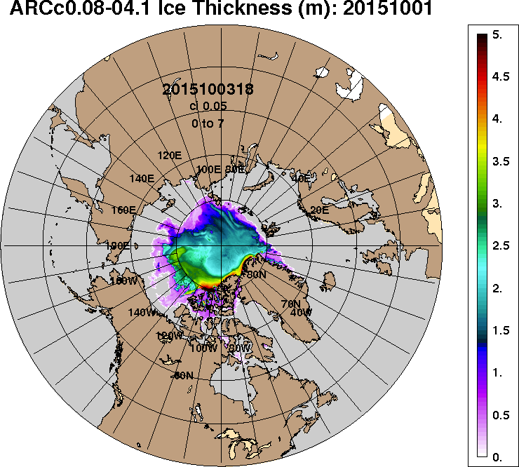
In other words, no new laws are needed and action can and should be taken now, as this blog has pointed out for years, e.g. in this 2014 post that featured the image below.


The threat of methane eruptions from the Arctic Ocean seafloor calls for urgent action

This blog has repeatedly pointed at another reason why especially America must act, and must do so rapidly, comprehensively and effectively. In October 2015, oceans reached record high temperatures, especially on the Northern Hemisphere, as illustrated by the image below.

Northern Hemisphere October ocean temperatures based on NOAA 1880-2015 data - plot area goes from 1900 to 2050 and from -1 to 4 degrees Celsius above baseline, i.e. compared to the period 1901-2000, the 20th century average.
Above image features a trendline showing that oceans on the Northern Hemisphere could, by the year 2043, be 4°C or 7.2°F warmer than the 20th century average. Increasingly, methane levels over the Arctic Ocean are showing strong increases from October onward, as huge amounts of ocean heat are reaching the seafloor of the Arctic Ocean from that month onward.

North America contributes strongly to accelerating warming of the Arctic Ocean. The Coriolis Effect makes that high levels of emissions originating from North America are extending over the Atlantic Ocean, and are warming up waters off the east coast of North America, as illustrated by the image below.

Top left: CO2 414 ppb green circle, up to 433 ppm in New Jersey. Top right: CO 274 ppb green circle, up to 890 ppb in New Jersey. Bottom left: Jet Stream 250 hPa. Bottom right: Sea surface temperature anomaly 8.5°C/15.3°F green circle.
2015 maximum nightly sea surface temperature anomaly
Carbon dioxide emissions are important, but also relevant are other emissions such as carbon monoxide that depletes hydroxyl, making it harder for methane to be oxidized.

As emissions keep rising, the Gulf Stream will carry ever warmer water into the Arctic Ocean, resulting in greater melting of the sea ice and associated albedo changes that in turn accelerate warming in the Arctic.

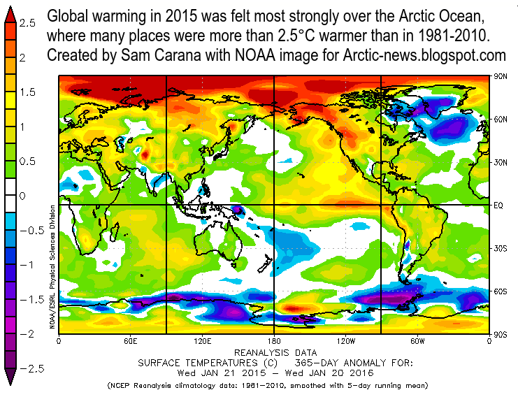
Surface temperature anomaly Jan 21, 2015 - Jan 20, 2016
 
This is further illustrated by the images on the right. The top image shows 2015 maximum nightly sea surface temperature anomalies, with anomalies of 5°C off the North American east coast as well as in the Arctic Ocean.

The second image on the right illustrate the extent at which warming in the Arctic Ocean is accelerating, compared to the rest of the world. The image also shows the cold freshwater lid over the North Atlantic.

Temperature anomaly forecast for January 28, 2016
 
As the temperature difference between the Arctic and the equator decreases, the jet stream gets more elongated, at times moving all across the Arctic Ocean. This is one of a multitude of feedbacks that contribute to accelerating warming of the Arctic Ocean. The result is illustrated by the third image on the right, showing strong warming over most of the Arctic Ocean, while at the same time some places on land at higher latitudes north are experiencing extremely cold conditions.

descending cold freshwater on January 25, 2016
Another one of such feedbacks is that warmer water off the coast of North America will result in stronger winds moving over the North Atlantic toward the Arctic Ocean. This can also speed up ocean currents, so it can result in more heat being carried toward the Arctic Ocean both in the atmosphere and the water.

Meltwater from glaciers and sea ice can descend along the edges of Greenland into the North Atlantic, forming a cold freshwater lid on the North Atlantic, where it accumulates at the surface over the years, as illustrated by the image on the right that points at a -4°C or -7.1°F anomaly compared to 1981-2011.

cold freshwater lid over the North Atlantic
In addition, precipitation (rain, snow, hail, fog, etc.) can further contribute to expansion of this cold freshwater lid over the North Atlantic, as illustrated by the images on the right.

While this cold freshwater may constitute a barrier that slows the flow of warm water toward the Arctic Ocean at the surface, the danger is that it prevents heat transfer to the atmosphere from warm water flowing below the sea surface, with the net result of more heat arriving in the Arctic Ocean.

Furthermore, if this cold freshwater lid also prevents water from sinking deeper in the North Atlantic, this may also contribute to more warm water arriving in the Arctic ocean, as illustrated by the bottom image on the right.

Such feedbacks can dramatically accelerate warming of Arctic Ocean, resulting in heat destabilizing sediments that can contain huge amounts of methane.

In conclusion, America must take the lead in action on climate change. It's fair to do so, it will benefit everyone, there are legal obligations to do so and there is great urgency to act in the light of looming methane eruptions from the seafloor of the Arctic Ocean.

The situation is dire and calls for comprehensive and effective action, as described at the Climate Plan


In October 2015, oceans reached record high temperatures, especially on the Northern Hemisphere. The image features a...
Posted by Sam Carana on Saturday, January 23, 2016

Thursday 17 December 2015

Paris Agreement

At the Paris Agreement, nations committed to strengthen the global response to the threat of climate change by holding the increase in the global average temperature to well below 2°C above pre-industrial levels and to pursue efforts to limit the temperature increase to 1.5°C above pre-industrial levels.


How much have temperatures risen already? As illustrated by above image, NASA data show that during the three-month period from September through November 2015, it was ~1°C warmer than it was in 1951-1980 (i.e the baseline).

A polynomial trend based on the data from 1880 to 2015 for these three months indicates that a temperature rise of 1.5°C compared to the baseline will be reached in the year 2024.

Let's go over the calculations. The trendline shows it was ~0.3°C colder in 1900 compared to the baseline. Together with the current ~1°C rise, that implies that since 1900 there's been a rise of 1.3°C compared to the baseline. This makes that another rise of 0.2°C by 2024, as pointed at by the trendline, would result in a joint rise in 2024 of 1.5°C compared to the baseline.


The situation is even more worse than this. The Paris Agreement seeks to avoid a temperature increase of 1.5°C above pre-industrial levels. When we include temperature rises from pre-industrial levels to the year 1900, it becomes evident that we have already surpassed a rise of 1.5°C since pre-industrial levels. This is illustrated by above image, earlier added at How much time is there left to act? (see notes there) and by the graph below, from a recent post by Michael Mann, who adds that ~0.3°C greenhouse warming had already taken place by the year 1900. 
~0.3C greenhouse warming had already taken place by 1900, and ~0.2C warming by 1870
Let's add things up again. A rise of ~0.3°C before 1900, a further rise of 0.3°C from 1900 to the baseline (1951-1980) and a further rise of ~1°C from the baseline to date, together that adds up to a rise of ~1.6°C from pre-industrial levels.

In other words, we have already surpassed a rise of 1.5°C from pre-industrial levels by 0.1°C.

The trendline indicates that a further rise of 0.5°C will take place by the year 2030, i.e. that without comprehensive and effective action, it will be 2°C warmer than pre-industrial levels before the year 2030.

Full wrath of emissions yet to come

The full wrath of global warming is yet to come and the situation is even more threatening than pictured above, for the following reasons:
  1. Half of global warming has until now been masked by aerosols, particularly sulfates that are emitted when some of the dirtiest fossil fuels are burnt, such as coal and bunker oil. As we make the necessary shift to clean energy, the masking effect that comes with those emissions will disappear. 
  2. As Ricke and Caldeira point out, the carbon dioxide that is released now will only reach its peak impact a decade from now. In other words, we are yet to experience the full wrath of the carbon dioxide emitted over the past decade. 
  3. The biggest threat comes from temperature peaks. People in some parts of the world will be hit  harder, especially during summer peaks, as discussed in the next section of this post. As temperatures rise, the intensity of such peaks will increase.
    The image on the right illustrates this with a forecast for December 25, 2015, showing extreme weather for North America, with temperatures as low as 30.6°F or -0.8°C in California and as high as 71.5°F or 22°C in North Carolina. 
  4. Feedbacks such as rapid albedo changes in the Arctic and large amounts of methane abruptly released from the Arctic Ocean seafloor could dramatically accelerate the temperature rise. Furthermore, water vapor will increase by 7% for every 1°C warming. Water vapor is one of the strongest greenhouse gases, so increasing water vapor will further contribute to a non-linear temperature rise. The resulting temperature rises threaten to be non-linear, as discussed in the final section of this post.  
Situation even worse for some

Such temperature rises will hit some people more than others. For people living on the Northern Hemisphere, the outlook is worse than for people on the Southern Hemisphere.

NOAA data show that the November global land and ocean temperature anomaly was 0.97°C, while the 3-month global land and ocean temperature anomaly was 0.96°C. The 12-month anomaly on November 2015 on land on the Northern Hemisphere (where most people live) was 1.39°C, as shown on the image below, while the trendline shows that for people living on the Northern Hemisphere, a 1.5°C rise compared to 1910-2000 could be reached as early as in 2017.


Similarly, the outlook is worse for people living in regions that are already now experiencing high temperatures during the summer peaks. As said, as temperatures rise, the intensity of such peaks will increase.

Feedbacks in the Arctic

The image below, from an earlier post, depicts the impact of feedbacks that are accelerating warming in the Arctic, based on NASA data up to November 2013, and their threat to cause runaway global warming. As the image shows, temperatures in the Arctic are rising faster than elsewhere in the world, but global warming threatens to catch up as feedbacks start to kick in more. The situation obviously has deteriorated further since this image was created in November 2013.
[ click on image at original post to enlarge ]
Above image, from an earlier post, depicts the impact of feedbacks that are accelerating warming in the Arctic, based on NASA data up to November 2013. The image shows that temperatures in the Arctic are rising faster than elsewhere in the world. Global warming threatens to catch up as feedbacks start to kick in more, triggering runaway global warming. The situation obviously has deteriorated further since this image was created in November 2013.

The image below shows sea surface temperature anomalies on the Northern Hemisphere in November.


The image below gives an indication of the high temperatures of the water beneath the sea surface. Anomalies as high as 10.3°C or 18.5°F were recorded off the east coast of North America (green circle on the right panel of the image below) on December 11, 2015, while on December 20, 2015, temperatures as high as 10.7°C or 51.3°F were recorded near Svalbard (green circle on the right panel of the image below), an anomaly of 9.3°C or 16.7°F.


This warm water is carried by the Gulf Stream into the Arctic Ocean, threatening to unleash huge amounts of methane from its seafloor. The image below illustrates the danger, showing huge amounts of methane over the Arctic Ocean on December 10, 2015.


Methane is released over the Arctic Ocean in large amounts, and this methane is moving toward the equator as it reaches high altitudes. The image below illustrates how methane is accumulating at higher altitudes.


Above image shows that methane is especially prominent at higher altitudes recently, having pushed up methane levels by an estimate average of 9 ppb or some 0.5%. Annual emissions from hydrates were estimated to amount to 99 Tg annually in a 2014 post (image below).


An additional 0.5% of methane represents an amount of some 25 Tg of methane. This comes on top of the 99 Tg of methane estimated in 2014 to be released from hydrates annually. 

The situation is dire and calls for comprehensive and effective action as described at the Climate Plan.


Links

- How Close Are We to 'Dangerous' Planetary Warming? By Michael Mann, December 24, 2015http://www.huffingtonpost.com/michael-e-mann/how-close-are-we-to-dangerous-planetary-warming_b_8841534.html

- Maximum warming occurs about one decade after a carbon dioxide emission, by Katharine L Ricke and Ken Caldeira (2014)
http://iopscience.iop.org/1748-9326/9/12/124002/article

- How much time is there left to act?
http://arctic-news.blogspot.com/p/how-much-time-is-there-left-to-act.html

During the three-month period from September through November 2015, it was 1°C warmer than it was in 1951-1980,...
Posted by Sam Carana on Wednesday, December 16, 2015

Friday 23 October 2015

September 2015 Sea Surface Warmest On Record

Arctic Sea Ice Extent Growth Seals Off Arctic Ocean


Arctic sea ice increased rapidly in October 2015, after reaching its annual minimum in September. As the image below shows, the growing sea ice extent has effectively sealed off the Arctic Ocean from the atmosphere, resulting in less evaporation and heat transfer from the ocean to the atmosphere.

The Naval Research Laboratory 30-days animation (up to October 22, with forecast added up to October 30) on the right shows that sea ice has grown in extent, adding plenty of very thin sea ice, while the existing ice has hardly increased its thickness.

The Buffer Has Gone

Thick sea ice used to extend meters below the sea surface in the Arctic, where it could consume massive amounts of ocean heat through melting this ice into water. As such, thick sea ice acted as a buffer. Over the years, Arctic sea ice thickness has declined most dramatically. This means that the buffer that used to consume massive amounts of ocean heat carried by sea currents into the Arctic Ocean, has now largely gone.

Latent heat loss, feedback #14 on the Feedbacks page
Cold Freshwater Lid on North Atlantic

Meanwhile, especially from 2012, huge amounts of freshwater have run off Greenland, with the accumulated freshwater now covering a huge part of the North Atlantic, acting as a lid that prevents ocean heat to evaporate from the North Atlantic.


Since it's freshwater that is now covering a large part of the surface of the North Atlantic, it will not easily sink in the very salty water that was already there. The water in the North Atlantic was very salty due to the high evaporation, which was in turn due to high temperatures and strong winds and currents. Freshwater tends to stay on top of more salty water, even though the temperature of the freshwater is low, which makes this water more dense. The result of this stratification is less evaporation in the North Atlantic, and less transfer of ocean heat to the atmosphere, and thus lower air temperatures than would have been the case without this colder surface water.

Cold freshwater lid on North Atlantic, feedback #28 on the Feedbacks page
The cold lid over the North Atlantic has meanwhile expanded. Greenland has been experiencing wild weather swings this month, with temperatures shifting from one extreme end of the scale to the other end. The image below shows temperature anomalies on October 17 (left panel), October 23 (center panel) and a forecast for October 30 (right panel). Temperatures are forecast to swing back to the extreme high end of the scale, pushing up temperature anomalies for the Arctic as a whole to as high as 2.37°C on October 30, 2015.

Wild weather swings causing methane releases, feedback #21 on the Feedbacks page
These wild weather swings over Greenland threaten to cause cracks in the ice, with methane hydrates in the ice becoming destabilized, resulting in releases of huge amounts of methane from hydrates and free gas into the atmosphere, as earlier discussed as feedback #21 on the Feedbacks page.

Strong winds have further contributed to extend the cold lid over the North Atlantic, while also making cold air flow from Greenland over the North Atlantic. This is illustrated by the image below, depicting the situation on October 23, 2015, with the left panel showing surface wind speed, while the right panel shows the resulting sea surface temperature anomalies. 


The video below shows surface wind speed forecasts in the Arctic from October 25 to November 1, 2015.


Ocean Temperature Rise

NOAA analysis shows that the global sea surface in September 2015 was the warmest on record, at 0.81°C (1.46°F) above the 20th century average of 16.2°C (61.1°F). On the Northern Hemisphere, the anomaly was 1.07°C (1.93°F).

[ click on image to enlarge ]
Of all the excess heat resulting from people's emissions, 93.4% goes into oceans. Accordingly, the temperature of oceans has risen substantially over the years and - without action - the situation only looks set to get worse.

The Threat

As ocean temperatures continue to rise, especially in the North Atlantic, the Gulf Stream will keep carrying ever warmer water from the North Atlantic into the Arctic Ocean. Without the buffer of thick sea ice to consume the increasing amount of ocean heat, the threat is that ocean heat will increasingly reach the seafloor and unleash huge methane eruptions from destabilizing clathrates. Such large methane eruptions will then warm the atmosphere at first in hotspots over the Arctic and eventually around the globe, while also causing huge temperature swings and extreme weather events, contributing to increasing depletion of fresh water and food supply, as further illustrated by the image below, from an earlier post.
[ click on image at original post to enlarge ]

October 2015 Sea Surface Temperature Update

The North Atlantic continues to be very warm. Sea surface temperature anomalies were as high as 7.9°C or 14.2°F at a location off the east coast of North America on October 22, 2015. Anomalies were 8.1°C or 14.5°F at that same spot on October 16, 2015.


Sea surface temperature anomalies were as high as 7.5°C or 13.6°F at a location near Svalbard on October 25, 2015. On October 9, 2015, sea surface temperatures were as high as 13.1°C or 55.6°F at that same location near Svalbard (marked by green circle on image below), an anomaly of 9.5°C or 17.2°F. These temperatures indicate that the water can be much warmer below the surface than at the surface, and that this warm water is transported by the Gulf Stream below the surface of the North Atlantic into the Arctic Ocean. The animation below switches between the above two dates and also shows that the cold freshwater lid on the North Atlantic has meanwhile extended further south.


In the Bering Strait, warm water also keeps flowing into the Arctic Ocean. At the location marked by the green circle on the image below, sea surface temperatures were as high as 7.3°C or 45.1°F on October 22, 2015, an anomaly of 5.7°C or 10.2°F.


Methane

The images below show high methane concentrations over the Arctic.


Above image shows methane levels at low altitude on October 22, 2015. Because of its height, there are no data at this altitude for Greenland. The image below shows methane concentrations at a higher altitude, with high methane levels showing up over Greenland on October 16, 2015.


Climate Plan

The situation is dire and calls for comprehensive and effective action, as discussed at the Climate Plan.

Malcolm Light comments

GLOBAL EXTINCTION IS NOW SIX YEARS CLOSER

The following comments refer to Figure 224 below. All historical floating ice appears to have been lost in the Arctic by September 2015 so we can assume that the 5+ year old ice pack has largely gone by this time. The 5+ year old ice pack was only predicted to melt back by 2021.7 consequently this year's volume of ice melting has occurred 6 years earlier than the previous prediction. The previous estimate of the final loss of 1 year Arctic floating ice from polynomial data was 2037.7 which now corrects to 2031.7, 16 years in the future.

Previous estimates of when the average atmospheric global temperature anomaly increase would reach 6°C was 2034.7, by which time massive global extinction would be proceeding. The new corrected time for this event is 2034.7 - 6 = 2028.7 which is 13 years in the future. During the major Permian Extinction event, which was caused by a massive methane build-up in the atmosphere, the mean surface atmospheric temperature increased by 5°C over 13 years. As the present mean global surface atmospheric temperature is already greater than 1°C hotter than the mean, we will be looking at at least a 6°C temperature increase by 2028 with its associated global extinction event. This is a frightening correlation between the new predicted 6°C average global surface atmospheric temperature rise and what is known to have occurred during the major Permian extinction event, both of which were caused by a massive buildup of methane in the atmosphere. We are clearly in for a very rough-hot ride in the next decade as the terminal global extinction event approaches.

Malcolm P.R. Light (Dr)
Earth Scientist
Figure 224. Arctic sea ice melt back times estimated from area, volume and thickness anomalies compared to various extinction zones defined by the global atmosphere temperature field. Credit: Malcolm Light. Click on image to enlarge.

Related

- Ocean Temperature Rise
http://arctic-news.blogspot.com/2014/10/ocean-temperature-rise.html

- Ocean Temperature Rise Continues

- Gulf Stream brings ever warmer water into Arctic Ocean
http://arctic-news.blogspot.com/2015/06/gulf-stream-brings-ever-warmer-water-into-arctic-ocean.html

- The Mechanism leading to Collapse of Civilization and Runaway Global Warming
http://arctic-news.blogspot.com/p/the-mechanism.html

- The Threat of Global Warming causing Near-Term Human Extinction
http://arctic-news.blogspot.com/p/threat.html

- Warming Arctic Ocean Seafloor Threatens To Cause Huge Methane Eruptions
http://arctic-news.blogspot.com/2015/09/warming-arctic-ocean-seafloor-threatens-to-cause-huge-methane-eruptions.html

- Climate Plan
http://arctic-news.blogspot.com/p/plan.html


NOAA analysis shows that the global sea surface in September 2015 was the warmest on record, at 0.81°C (1.46°F) above...
Posted by Sam Carana on Friday, October 23, 2015

Saturday 10 October 2015

Arctic Sea Ice 2015 - update 11

Arctic sea ice extent has been growing rapidly recently. The image below shows extent up to October 9, 2015 (marked by red dot).


Below is a comparison of sea ice thickness as on October 6, for the years (from left to right) 2012, 2013, 2014 and 2015. The comparison shows that decline has been strongest where sea ice used to be the thickest, i.e. over 3 meters thick.


One of the reasons why the thickest Arctic sea ice has declined so dramatically over the years is the rising ocean heat that is melting the sea ice from underneath. The image below illustrates the situation on October 5, 2015, when sea surface temperature anomalies were as high as 6.4°C, 7.4°C and 7.3°C (11.5°F 13.2°F and 13.1°F) off the North American coast, and as high as 9.4°C (16.8°F) near Svalbard.


Water temperatures are very high in the Arctic, as further illustrated by the image below showing Arctic sea surface temperature anomalies as at October 9, 2015.


Rising ocean heat is further illustrated by the graph below, showing August sea surface temperature anomalies on the Northern Hemisphere over the years.
The situation is very dangerous, due to feedbacks and their interaction. The thicker sea ice used to act as a buffer, consuming ocean heat in the melting process. Without thicker sea ice, ocean heat threatens to melt the sea ice from below right up to the surface, causing the entire sea ice to collapse. As the sea ice declines, more open water will give rise to stronger winds and waves.

Furthermore, sunlight that was previously reflected back into space will instead be absorbed by the water, causing rapid rise of the temperature of the water. In places such as the East Siberian Arctic Shelf, the water is on a average only 50 m deep, so warmer water is able to reach the seafloor more easily there. As ocean heat keeps rising, there's a growing risk that heat will reach the Arctic Ocean seafloor and destabilize methane hydrates in sediments at the Arctic Ocean seafloor.

The image below shows a non-linear trend that is contained in the temperature data that NASA has gathered over the years, as described in an earlier post. A polynomial trendline points at global temperature anomalies of over 4°C by 2060. Even worse, a polynomial trend for the Arctic shows temperature anomalies of over 4°C by 2020, 6°C by 2030 and 15°C by 2050, threatening to cause major feedbacks to kick in, including albedo changes and methane releases that will trigger runaway global warming that looks set to eventually catch up with accelerated warming in the Arctic and result in global temperature anomalies of 16°C by 2052.

[ click on image to enlarge ]
The situation is dire and calls for comprehensive and effective action, as discussed at the Climate Plan.

Comparison of sea ice thickness on October 6, for the years (from left to right) 2012, 2013, 2014 and 2015, shows that...

Posted by Sam Carana on Saturday, October 10, 2015

Friday 25 September 2015

Warming Arctic Ocean Seafloor Threatens To Cause Huge Methane Eruptions

Rapidly growing 'Seal' over Arctic Ocean


Arctic sea ice extent and especially concentration are now growing rapidly, as illustrated by the Naval Research Lab animation on the right.

This means that the sea ice is effectively sealing off the water of the Arctic Ocean from the atmosphere, reducing the chances of transfer of ocean heat from the water to the atmosphere. Conversely, the risk grows that ocean heat will reach the seafloor.

Furthermore, this seal makes that less moisture evaporates from the water, which together with the change of seasons results in lower hydroxyl levels at the higher latitudes of the Northern Hemisphere, in turn resulting in less methane being broken down in the atmosphere over the Arctic.

Rising Ocean Heat


Water temperatures are very high in the Arctic. Above image shows Arctic sea surface temperature anomalies as at September 24, 2015. The risk of ocean heat reaching the Arctic Ocean seafloor has increased significantly over the years, due to rising ocean heat, as illustrated by the graph below, showing August sea surface temperature anomalies on the Northern Hemisphere over the years. 

[ from the earlier post: August 2015 Had Highest Sea Surface Temperature on Record ]
Ocean heat is increasing because people's emissions are making the planet warmer and more than 93% of the extra heat goes into the oceans.

Ocean temperatures have been measured for a long time. Reliable records go back to at least 1880. Ever since records began, the oceans were colder than they are now. Back in history, there may have been higher temperature peaks - the last time when it was warmer than today, during the Eemian Period, peak temperature was a few tenths of a degree higher than today. In many ways, however, the situation now already looks worse than it was in the Eemian. "The warm Atlantic surface current was weaker in the high latitude during the Eemian than today", says Henning Bauch. Furthermore, carbon dioxide levels during the Eemian were well under 300 ppm. So, there could well have been more pronounced seasonal differences then, i.e. colder winters that made that the average ocean temperature didn't rise very much, despite high air temperature in summer. By contrast, today's high greenhouse levels make Earth look set for a strong ocean temperature rise.

And indeed, this is illustrated by above image, showing a polynomial trendline that points at a rise of almost 2°C by 2030. This trendline is contained in ocean temperature data from 1880 for the August Northern Hemisphere sea surface temperature anomalies.

Cold Freshwater 'Lid' on North Atlantic


Note that the above ocean temperature graph and the above video only show sea surface temperatures. Underneath the surface, water can be even warmer. The Gulf Stream reaches its maximum temperatures off the North American coast in July. It can take some four months for this heat to travel along the Gulf Coast and reach destinations farther in the Arctic Ocean. Water warmed up off Florida in July may only reach waters beyond Svalbard by October or November.

The image below shows that on August 22, 2015, at a location near Florida marked by the green circle, sea surface temperatures were as high as 33.4°C (92.1°F), an anomaly of 3.8°C (6.8°F).


The image below shows sea surface temperatures on August 22, 2015, as an indication of the huge amount of ocean heat has accumulated in the Atlantic Ocean off the coast of North America.


The huge amounts of energy entering the oceans translate into higher temperatures of the water and of the air over the water, as well as higher waves and stronger winds.

Ocean heat carried by the Gulf Stream from Florida via the North Atlantic into the Arctic Ocean.
The image on the left shows that on August 25, 2015, sea surface temperatures near Svalbard were recorded as high as 17.3°C (63.1°F), as marked by the green circle, a 12.1°C (21.8°F) anomaly.

This indicates that ocean heat did reach that location from underneath the sea surface. In other words, subsurface temperatures of the water carried along by the Gulf Stream can be substantially higher than temperatures of the water at the surface, and this can be the case for the water all the way from the coast of North America to the Arctic Ocean.

The Gulf Stream keeps pushing much of this very warm water north, into the Arctic Ocean, where it threatens to unleash huge methane eruptions from the Arctic Ocean seafloor.

The combination image below shows the Gulf stream carrying warm water from the coast of North America into the Arctic Ocean on September 12, 2015, and sea surface reaching temperatures as high as 14.6°C (58.3°F) that day at a location near Svalbard (marked by green circle), an 9.8°C (17.6°F) anomaly

[ click on image to enlarge ]
The combination image below shows that sea surface temperature anomalies still are very high. The left panel shows that anomalies on September 25, 2015 were as high as +6°C (+10.8°F) in the North Atlantic (location marked by green circle), compared to 1901-2011. The right panel shows anomalies on September 26, 2015, in the North Atlantic of +0.81°C (+1.46°F) and in the North Pacific of +1.02°C (+1.84°F), compared to 1971-2000.


Below is an update on the situation. On October 5, 2015, sea surface temperature anomalies were as high as 6.4°C, 7.4°C and 7.3°C (11.5°F 13.2°F and 13.1°F) off the North American coast, and as high as 9.4°C (16.8°F) near Svalbard.


Speed of surface water was as high as 1.6 m/s (3.6 mph) on October 5, 2015. This wasn't as high as some of the speeds reached earlier in the year (a speed of 2.16 m/s or 4.7 mph was recorded on August 15, 2015), but it does indicate how strong the Gulf Stream still is at this time of year. Water speed slows down as the Gulf Stream progresses toward the Arctic Ocean. While speeds as high as 0.22 m/s and 0.24 m/s (0.5 mph) were recorded near Svalbard and Norway, overall speed was a lot lower in this part of the Atlantic.

What is making the situation worse is depicted in the images below. From 2012, huge amounts of freshwater have run off Greenland, with the accumulated freshwater now covering a huge part of the North Atlantic, as illustrated by the image below. 


Since it's freshwater that is now covering a large part of the surface of the North Atlantic, it will not easily sink in the very salty water that was already there. The water in the North Atlantic was very salty due to the high evaporation, which was in turn due to high temperatures and strong winds and currents. As said, freshwater tends to stay on top of more salty water, even though the temperature of the freshwater is low, which makes this water more dense. The result of this stratification is less evaporation in the North Atlantic, and less transfer of ocean heat to the atmosphere, and thus lower air temperatures than would have been the case without this colder surface water.


As meltwater accumulates at the surface of the North Atlantic, will it slow down the Gulf Stream?

More elongated curves and eddies forming where the meltwater meets the Gulf Stream appears to make that it will indeed take longer for surface water to travel from the coast of North America to the Arctic Ocean. However, the speed reached within such eddies may actually be higher. After all, the amount of extra heat that enters the oceans keeps growing and this extra energy will likely translate into warmer water carried in greater volumes and at higher speed by the Gulf Stream underneath the surface of the North Atlantic into the Arctic Ocean, be it that the more curved patterns of the currents will increase the overall time it takes for water to travel the distance, especially at the surface.

Importantly, as global warming continues to heat up the oceans, the accumulated freshwater at the surface of the North Atlantic makes that less ocean heat can be transferred from the water to the atmosphere there, i.e. the freshwater is acting like a lid. Similarly, the Arctic sea ice is acting as a seal over the Arctic Ocean, as seasons change. In conclusion, the highest temperatures of the water of the Arctic Ocean, especially at greater depth, are yet to be reached this year.


Above image illustrates that, while Arctic sea water at the surface reaches its highest temperatures in the months from July to September, water at greater depth reaches its highest temperatures only in October through to the subsequent months.

Methane Eruptions from Arctic Ocean Seafloor

In the Arctic Ocean, this more salty newly-arriving warm water will tend to dive under the freshwater that has formed from the melting of sea ice over the past few months. The danger is thus that warmer water will be pushed into the Arctic Ocean at lower depth, and that it will reach the seafloor of the Arctic Ocean.

Huge amounts of methane are contained in sediments on the Arctic Ocean seafloor. Ice acts like a glue, holding these sediments together and preventing destabilization of methane hydrates. 

Pingos and conduits. Hovland et al. (2006)
Warmer water reaching these sediments can penetrate them by traveling down cracks and fractures in the sediments, and reach the hydrates. The image on the right, from a study by Hovland et al., shows that hydrates can exist at the end of conduits in the sediment, formed when methane did escape from such hydrates in the past. Heat can travel down such conduits relatively fast, warming up the hydrates and destabilizing them in the process, which can result in huge abrupt releases of methane.

Heat can penetrate cracks and conduits in the seafloor, destabilizing methane held in hydrates and in the form of free gas in the sediments.

Elsewhere, methane hydrates will typically be located at great depth, making it more difficult for ocean heat to reach them. In the Arctic, much of the water is very shallow. The East Siberian Arctic Shelf (ESAS) is on average only 50 m deep, making it easier for heat to reach the seafloor and also making that methane that escapes will have to travel through less water, reducing the chances that methane will be broken down by microbes on the way up through the water. Furthermore, hydroxyl levels are very low over the Arctic, making that the methane will not quickly be broken down in the atmosphere over the Arctic either.

The big melt in Greenland and the Arctic in general is causing further problems. Isostatic adjustment following melting can contribute to seismic events such as earthquakes, shockwaves and landslides that can destabilize methane hydrates contained in sediments on the Arctic Ocean seafloor.


Above image shows methane levels as high as 2554 parts per billion, on the morning of September 23, 2015, in the bottom panel, and strong methane releases over the ESAS, as indicated by the solid magenta-colored areas in the top panel, on the afternoon of the previous day at lower altitude. These are indications of methane releases from the seafloor of the Arctic Ocean. Strong winds over the ESAS, as the image below shows, may have contributed, by mixing warm water down to the seafloor.


On the morning of September 25, 2015, methane reached levels as high as 2629 ppb, while mean global level reached a record high 1846 ppb. The video below, created with Climate Reanalyzer images,  shows strong winds over the Arctic for the period September 26 to October 3, 2015.


The video below, created by Cameron Forge with Climate Reanalyzer images, shows Arctic air temperature anomalies end September - early October, 2015.


Air Temperature Rise

NOAA data show that the year-to-date land surface temperature in July was 1.47°C above the 20thcentury average on the Northern Hemisphere in 2015. A polynomial trendline based on these data points at yet another degree Celsius rise by 2030, on top of the current level, which could make it 3.27°C warmer than in 1750 for most people on Earth by the year 2030, as illustrated by the image below.

Will it be 3.27°C warmer by the year 2030?
The image below shows a non-linear trend that is contained in the temperature data that NASA has gathered over the years, as described in an earlier post. A polynomial trendline points at global temperature anomalies of over 4°C by 2060. Even worse, a polynomial trend for the Arctic shows temperature anomalies of over 4°C by 2020, 6°C by 2030 and 15°C by 2050, threatening to cause major feedbacks to kick in, including albedo changes and methane releases that will trigger runaway global warming that looks set to eventually catch up with accelerated warming in the Arctic and result in global temperature anomalies of 16°C by 2052.
[ click on image to enlarge ]
The situation is dire and calls for comprehensive and effective action, as discussed at the Climate Plan.


In the Arctic Ocean, the more salty newly-arriving warm water will tend to dive under the freshwater that has formed...
Posted by Sam Carana on Friday, September 25, 2015