Showing posts with label sea surface temperature. Show all posts

Friday 10 July 2015

Arctic Sea Ice Collapse Threatens

The image below compares the Arctic sea ice thickness on July 14, 2012 (left panel) and on July 14, 2015 (right panel), using Naval Research Laboratory images.


The Naval Research Laboratory's 30-day animation below shows how this situation developed, ending with a forecast for July 17, 2015, run on July 9, 2015.


The dramatic decline of the sea ice, especially north of North America, is the result of a combination of factors, including:

  • very high levels of greenhouse gases over the Arctic Ocean
  • very high levels of ocean heat 
  • heatwaves over North America and Siberia extending high air temperatures over the Arctic Ocean
  • wildfires triggered by these heatwaves resulting in darkening compounds settling on snow and ice
  • very warm river water running into the Arctic Ocean, as illustrated by the image below.  


With still two months of melting to go before the sea ice can be expected to reach its minimum for 2015, the threat of sea ice collapse is ominous. The Arctic-News Blog has been warning for years about the growing chance of a collapse of the sea ice, in which case huge amounts of sunlight that previously were reflected back into space, as well as heat that previously went into melting the ice, will then instead have to be absorbed by the water, resulting in a dramatic rise of sea surface temperatures.

The image below shows the already very high sea surface temperature anomalies as at July 10, 2015.


More open water will then come with an increased chance of storms that can cause high sea surface temperatures to be mixed down all the way to seafloor of the Arctic Ocean, which in many cases is less than 50 m (164 ft) deep.

Meanwhile, ocean heat is accumulating off the coast of North America, as illustrated by the image below showing sea surface temperature as high as 31.8°C (89.24°F) on July 8-9, 2015.


Massive amounts of ocean heat will be carried by the Gulf Stream into the Arctic Ocean over the next few months. The combined result of high sea surface temperatures being mixed down to the seafloor and the ocean heat entering the Arctic Ocean from the Atlantic and Pacific Oceans can be expected to result in dramatic methane eruptions from the Arctic Ocean seafloor by October 2015.

Currently, methane levels are high, especially north of Greenland, as illustrated by the image below showing that on July 10, 2015 (am), levels as high as 2416 parts per billion were recorded at 6,041 m (19,820 ft) altitude, while mean methane levels also reached 1831 parts per billion at this altitude.


The situation is dire and calls for comprehensive and effective action, as discussed at the Climate Plan.


ARCTIC SEA ICE COLLAPSE THREATENSThis image compares the Arctic sea ice thickness on July 14, 2012 (left panel) and on...
Posted by Sam Carana on Friday, July 10, 2015

Thursday 18 September 2014

Warm water flowing into Arctic Ocean

by Harold Hensel

For the first time in thousands of years, warm water is flowing into the Arctic Ocean. Warm water from the deep ocean is showing up on surface images. There is no way to put this into the context of 'normal.' Historic temperatures have kept the Arctic frozen on an even keel for thousands of years. Even if there was a 'natural cycle' it has been completely overridden by the astonishing amount of pollution that is going into the atmosphere.


Over 90 percent of Earth's energy imbalance has been going into the oceans, almost unnoticed by people keeping track of the temperatures in the atmosphere. The warmer ocean water is going through the Bering Strait and into the Chukchi Sea, Barents Sea, East Siberian Sea and worst of all, the Laptev Sea.

The Gakkel Ridge crosses the Arctic Ocean from Greenland to the Laptev Sea, see earlier post
There are methane hydrate concentrations in all of these areas up to 1,500 feet deep for miles and miles. There are fractures here that give mantel methane a route to the surface that have been safely sealed by ice. The hydrates and seals are thawing.

In 2013, huge amounts of methane erupted over the Gakkel Ridge and
the Laptev Sea
in October, with levels as high as 2662 ppb on November 9.
In 2014, levels over 2400 ppb were recorded on September 14, 15 and 16.

On the Greenland side, warm water is flowing into the Arctic from the Labrador, Greenland and Norway seas. The international SWERUSs-C3 expedition on the icebreaker Oden is recording 'mega flares' of methane. There are many factors involved in warming the Arctic Ocean, but warm water flowing into it is one of the worst.

Harold Hensel
Cedar Rapids

Thursday 4 September 2014

State Of Extreme Emergency

by Malcolm Light

PRESIDENT OBAMA MUST DECLARE A STATE OF EXTREME NATIONAL EMERGENCY AND CEASE ORCHESTRATING A WAR WITH RUSSIA. HE MUST RECALL HIS ENTIRE ARMY AND NAVY PERSONNEL TO THE UNITED STATES TO BEGIN A MASSIVE CONVERSION OF THE US ENERGY SYSTEM TO SOLAR AND WIND POWER. THIS CONVERSION MUST RESULT IN ALL 600 COAL POWER STATIONS AND NUCLEAR STATIONS BEING COMPLETELY SHUT DOWN IN THE NEXT 5 TO 10 YEARS. ALL SURFACE TRANSPORT BOTH PRIVATE AND PUBLIC MUST BE ENTIRELY ELECTRIFIED AND AIR TRANSPORT CONVERTED TO METHANE OR HYDROGEN FUEL. IF THIS IS NOT DONE, HUMANITY WILL BE FACING TOTAL EXTINCTION IN AN ARCTIC METHANE FIRESTORM BETWEEN 2040 AND 2050.


The US and Canada must cut their global emissions of carbon dioxide by 90% in the next 10 to 15 years, otherwise they will be become an instrument of mass destruction of the Earth and its entire human population. Recovery of the United States economy from the financial crisis has been very unsoundly based by the present Administration on an extremely hazardous "all of the above" energy policy that has allowed continent wide gas fracking, coal and oil sand oil mining and the return of widespread drilling to the Gulf. Coast. This large amount of fossil fuel has to be transported and sold which has caused extensive spills, explosions and confrontations with US citizens over fracking and the Keystone XL pipeline. Gas fracking is in the process of destroying the entire aquifer systems of the United States and causing widespread earthquakes. The oil spills are doing the same to the surface river run off.

We are now facing a devastating final show down with Mother Nature, which is being massively accelerated by the filthy extraction of fossil fuels by US and Canada by gas fracking, coal and tar sand mining and continent wide bitumen transport. The United States and other developed nations made a fatal mistake by refusing to sign the original Kyoto protocols. The United States and Canada must now cease all their fossil fuel extraction and go entirely onto renewable energy in the next 10 to 15 years otherwise they will be guilty of planetary ecocide - genocide by the 2050's.

The volume transport of the Gulf Stream has increased by three times since the 1940's due to the rising atmospheric pressure difference set up between the polluted, greenhouse gas rich air above North America and the marine Atlantic Air. The increasingly heated Gulf Stream with its associated high winds and energy rich weather systems then flows NE to Europe where it recently pummeled Great Britain with catastrophic storms. Other branches of the Gulf Stream then enter the Arctic and disassociate the subsea Arctic methane hydrate seals on subsea and deep high - pressure mantle methane reservoirs below the Eurasian Basin- Laptev Sea transition. This is releasing increasing amounts of methane into the atmosphere producing anomalous temperatures, greater than 20°C above average. Over very short time periods of a few days to a few months the atmospheric methane has a global warming potential from 1000 to 100 times that of carbon dioxide.


There are such massive reserves of methane in the subsea Arctic methane hydrates, that if only a few percent of them are disassociated, they will lead to a jump in the average temperature of the Earth's atmosphere by 10°C and produce a "Permian" style major extinction event which will kill us all. The whole northern hemisphere is now covered by a thickening atmospheric methane global warming veil that is spreading southwards at about 1 km a day and it already totally envelopes the United States. A giant hole in the equatorial ozone layer has also been discovered in the west Pacific which acts like an elevator transferring methane from lower altitudes to the stratosphere where it already forms a dense equatorial global warming stratospheric band that is spreading into the Polar regions.


During the last winter, the high Arctic winter temperatures and pressures have displaced the normal freezing Arctic Air south into Canada and the United States producing never before seen, freezing winter storms and massive power failures. When the Arctic ice cap finally melts towards the end of next year, the Arctic sea will be aggressively heated by the sun and the Gulf Stream. The cold Arctic air will then be confined to the Greenland Ice cap and the hot globally warmed Arctic air with its methane will flow south to the United States to further heat up the Gulf Stream, setting up an anticlockwise circulation around Greenland. Under these circumstances Great Britain and Europe must expect even more catastrophic storm systems, hurricane force winds and massive flooding after the end of next year due to a further acceleration in the energy transport of the Gulf Stream. If this process continues unchecked the mean temperature of the atmosphere will rise a further 8° centigrade and we will be facing global deglaciation, a more than 200 feet rise in sea level rise and a major terminal extinction event by the 2050's.


Tuesday 26 August 2014

Very warm waters are invading the Arctic Ocean

Global mean methane levels as high as 1836 parts per billion were recorded at several altitudes on August 24, 2014. Meanwhile, the Arctic Ocean continues to warm up. As the image below shows, the ocean heat is felt strongly on the Northern Hemisphere.
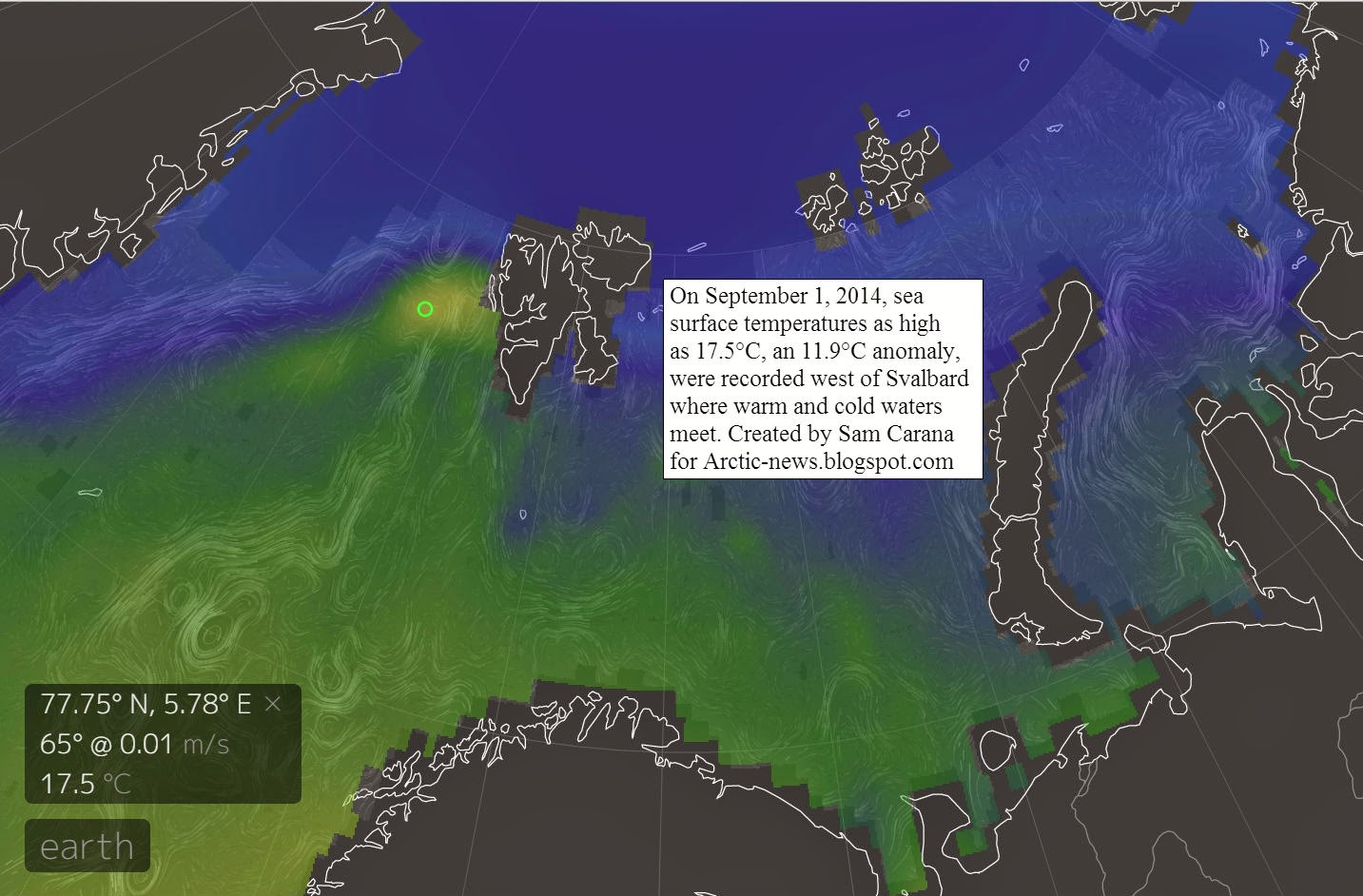
Very warm waters from the North Pacific and the North Atlantic Oceans are now invading the Arctic Ocean. Never before in human history have these waters been this warm. In the Arctic Ocean, this is causing very high sea surface temperatures, as shown on the image below.

[ click on image to enlarge ]
The very high temperatures threaten to trigger all kinds of feedbacks, as described in the image below.

Feedbacks in the Arctic
The big danger is that, as the seabed warms up, methane will erupt from hydrates in sediments under the Arctic Ocean. The situation is dire and calls for comprehensiev and effective action, as discussed at the Climate Plan blog.


Monday 4 August 2014

Warm waters threaten to trigger huge methane eruptions from Arctic Ocean seafloor

The evidence of abrupt high methane releases in the Arctic Ocean is accumulating. The graph below shows in situ methane measurements taken at the Barrow Observatory, including recent levels as high as close to 2200 parts per billion (ppb).


Satellite data picture a similarly dire situation. Global mean methane levels as high as 1831 ppb were recorded on the morning of July 30, 2014, while peak methane levels as high as 2330 ppb were recorded that morning. More recently, peak methane levels as high as 2522 ppb were recorded (on August 2, 2014).

IPCC/NOAA figures suggest that methane levels were rising by some 5 to 6 ppb annually, reaching 1814 ppb in 2013. While methane levels at lower altitudes have indeed shown little rise, much larger rises have been recorded at higher altitudes, as illustrated by the image below.


These high methane levels recorded at higher altitudes appear to be caused by the huge quantities of methane released from the seafloor of the Arctic Ocean during the period from end 2013 to early 2014. This methane has meanwhile risen to higher altitudes, while also descending to lower latitudes, wreaking havoc on weather patterns around latitude 60° North.

The releases of methane from the seafloor of the Arctic Ocean were caused by water that had warmed up strongly off the east coast of North America from June 2013. It took some months for this warm water to be carried by the Gulf Stream into the Arctic Ocean.


Meanwhile, very high sea surface temperatures are recorded in the Arctic Ocean, as above image shows, while warm water is carried into the Arctic Ocean by the Gulf Stream, as illustrated by the image below.


As said, the situation is dire and calls for comprehensive and effective action, as discussed at the Climate Plan blog.


Tuesday 24 June 2014

Earthquakes and Warm Water threaten Arctic

[ soucre: NOAA image - click to enlarge]
A major earthquake hit the Aleutian Islands, Alaska, on June 23, 2014.

The earthquake occurred at 51.797°N 178.760°E, 15 miles (24 km) southeast of Little Sitkin Island, Alaska, at a depth of 66.8 miles (107.5km).

The U.S. Geological Survey (USGS) earlier listed the earthquake at a magnitude of 8 on the Richter scale, but eventually gave the quake a magnitude of 7.9.

Initial tsunami warnings, as reflected by the two NOAA images on the right, were later cancelled, e.g. the Pacific Tsunami Warning Center in Hawaii said the earthquake’s epicenter was too deep to pose a tsunami threat to its coasts.

Indeed, earthquakes that occur at less depth, i.e. closer to the seafloor, pose a greater tsunami threat, as more energy will enter the sea as kinetic energy pushing up wave height propelled in the form of a tsunami.

Earthquakes that occur at greater depth pose other kinds of threats. When earthquakes hit deep under the sea floor, more energy will translate into shockwaves that can propagate over great distances through the Earth crust, particularly along fault lines.

[ source: NOAA image - click to enlarge]
In this case, the situation is particularly threatening for the Arctic Ocean. As the map below shows, the fault line where this earthquake hit extends through Siberia into the Laptev Sea and was hit by three earthquakes recently:

M 4.9 - East of Severnaya Zemlya
2014-06-22 23:58:24 UTC
Location 78.520°N 125.942°E
Depth 10.00 km (6.21 mi)

M 4.7 - Laptev Sea
2014-06-01 08:52:43 UTC
Location 75.012°N 133.665°E
Depth 10.00 km (6.21 mi)

M 4.8 - 172km N of Deputatskiy, Russia
2014-05-29 05:07:33 UTC
Location 70.844°N 139.761°E
Depth 10.00 km (6.21 mi)


A cluster of earthquakes that recently hit the Aleutian Islands shows up in green in the top right corner op above map. Also note the red dot on the right, respresenting a M 4.1 earthquake that hit the Sea of Okhotsk on June 22, 2014 (at 09:47:47 UTC, location 51.843°N 151.310°E), at a depth of 527.66 km (327.87 mi).

Earthquakes are a major threat for the Arctyic as they can destabilize methane hydrates contained in sediments under the seafloor of the Arctic Ocean.

The situation is the more dangerous given the warm sea water that threatens to enter the Arctic Ocean, as illustrated by the image below.


As the recent NOAA overview of the climate situation in May 2014 describes, combined average temperature over global land and ocean surfaces reached a record high for May, at 0.74°C (1.33°F) higher than the 20th century average. Across the oceans, the global monthly-averaged sea surface temperature was 0.59°C (1.06°F) higher than the 20th century average, marking the highest May temperature on record. This is further illustrated by the image below.

Meanwhile, the situation hasn't improved, as illustrated by the image below.


The NOAA image below shows sea surface temperature anomalies in the Arctic Ocean on June 23, 2014, with many areas showing anomalies above 8 degrees Celsius.


According to NOAA's Climate Prediction Center, there is about a 70% chance that El Niño conditions will develop during the Northern Hemisphere summer 2014 and an 80% chance it will develop a few months later.

As discussed in earlier posts, the sea ice is already very thin, and while ocean heat is melting the sea ice from beneath, the sun is warming up the ice from above. At this time of year, insolation in the Arctic is at its highest, as Earth reaches its maximum axial tilt toward the sun of 23° 26'. In fact, insolation during the months June and July is higher in the Arctic than anywhere else on Earth, as discussed at this earlier post.

Feedbacks further accelerate warming in the Arctic, as described in the earlier post Feedbacks in the Arctic. Temperature rises of the water close to the seafloor of the Arctic Ocean is very dangerous, as heat penetrating sediments there could cause hydrate destabilization, resulting in huge amounts of methane entering the atmosphere over the Arctic Ocean.

In conclusion, the situation is the Arctic is threatening to escalate into runaway warming and urgently requires comprehensive and effective action as discussed at the Climate Plan blog.

Monday 9 June 2014

Arctic Sea Ice Steep Decline Continues


Steep decline of the Arctic sea ice continues. The yellow line on the image below follows 2014 sea ice area up to June 5 and shows that sea ice area now is close to a record low for the time of the year.

[ click on image to enlarge ]
The Naval Research Laboratory image below compares sea ice concentration on May 14, 2014 (left) with the sea ice concentration forecast for June 15, 2014 (run on June 7, 2014, on the right).


Above image shows falling sea ice concentration, with low sea ice concentration extending to the center of the Arctic Ocean.

Low sea ice concentration at the center of the Arctic Ocean is an ominous sign; at last year's minimum, very little sea ice was left close to the North Pole, as discussed in an earlier post.

On the right is an image of the University of Bremen showing sea ice concentration on June 8, 2014 (click on the images to enlarge them).

Arctic sea ice already is very thin, as discussed in recent posts. The image below shows that the sea ice volume trend down to zero was confirmed for the months April and May 2014.

[ image by Andy Lee Robinson based on PIOMAS data, click on image to enlarge ]
The lowest sea ice volume for 2014 is expected to be reached in September, and - given the shape the ice is in now - will likely be one of the lowest minima on record. In fact, there is a chance that there will be no ice left whatsoever later this year. As illustrated by the image by Wipneus below, an exponential curve based on annual minima from 1979 points at zero ice volume end 2016, with the lower limit of the 95% confidence interval pointing at zero ice end of 2014.
As the sea ice disappears, a lot more heat will be absorbed by the Arctic Ocean. Sea ice reflects 50% to 70% of the incoming energy, describes NSIDC.org, but thick sea ice covered with snow reflects as much as 90% of the incoming solar radiation. Melting of snow creates melt ponds on the ice and because shallow melt ponds have an albedo of approximately 0.2 to 0.4, the surface albedo drops to about 0.75. As melt ponds grow and deepen, the surface albedo can drop to 0.15. The ocean reflects only 6% of the incoming solar radiation and absorbs the rest. Snow and ice decline comes with a further feedback in that all the energy that during the melt went into transforming ice into water will - in the absence of ice - now be absorbed by the ocean as well.

Accelerated Warming in the Arctic

[ from the post Near-Term Human Extinction ]
Such feedbacks are causing warming to accelerate in the Arctic Ocean, as depicted in above image and described in the earlier post Feedbacks in the Arctic. Much of the Arctic Ocean is very shallow and the seafloor is thus vulnerable to warming. The Gulf Stream can be expected to keep carrying warmer water into the Arctic Ocean, so the situation is dire, while extreme weather events such as heatwaves and cyclones can make the situation even worse.

The NOAA image below shows huge sea surface temperature anomalies all over the Northern Hemisphere on June 8, 2014.

[ click on image to enlarge ]
Large areas with sea surface temperature anomalies up to 8°C and higher show up in and around the Arctic Ocean, as further illustrated by the image below.

[ click on image to enlarge ]
The image below shows high sea surface temperature anomalies from February 21, 2014, up to June 9, 2014, on the Northern Hemisphere (red bars), next to global average anomalies (orange/shaded bars).


The global sea surface temperature anomaly is worrying (a 1.25°C anomaly was reached on May 22, 2014). See the NOAA website to compare this with earlier months. Note that on specific spots the anomaly is much higher, as illustrated by the images further above.

Warm surface waters in the Arctic sea ice spell bad news, given that the sea ice is already at or close to record lows, in terms of area and volume.

And as ocean heat threatens to melt the sea ice from beneath, the sun is now strongly warming up the ice from above. Insolation in the Arctic is at its highest at this time of year, as Earth reaches its maximum axial tilt toward the sun of 23° 26'. In fact, insolation during the months June and July is higher in the Arctic than anywhere else on Earth, as discussed at this earlier post.

The diminishing temperature difference between the equator and the North Pole reduces the speed at which the Jet Stream circumnavigates Earth and it makes the Jet Stream become wavier, increasing opportunities for cold air to escape from the Arctic and for warm air to move in. More extreme weather increases the chance of intense and prolonged heatwaves and fierce cyclones, storms and winds to hit the Arctic Ocean.

Making things even worsen, there is the prospect of an El Niño event, projected to occur later this year. According to NOAA (June 5, 2014), the chance of El Niño is 70% during the Northern Hemisphere summer and reaches 80% during the fall and winter. El Niño odds are even higher than this, according to this post at the Wunderground blog.


Methane

Temperature rises of the water close to the seafloor of the Arctic Ocean are very dangerous, as heat can penetrate sediments and cause hydrate destabilization. Huge amounts of methane are held in sediments at the seafloor, in the form of free gas and hydrates. In shallow waters, methane released from the seafloor can more easily enter the atmosphere without getting broken down by microbes in the water.

Methane levels are already very high. On June 6, 2014, mean global methane reached levels as high as 1809 ppb, with peaks as high as 2516 ppb.

Methane release from the seafloor of the Arctic Ocean will warm up the Arctic even further, triggering even more methane releases, heatwaves, wildfires and further feedbacks, in a spiral of runaway warming, threatening to cause starvation, destruction and extintion at massive scale across the globe.


Earthquakes

Earthquakes are a further worry. A huge amount of melting takes place in Greenland, as described in the post Ten Cubic Kilometers of Ice Lost From Jakobshavn Glacier in Less than One Month. As the ice disappears, a large weight is lefted from Greenland, causing the Earth's crust there to be lifted in a phenomenon referred to as isostatic rebound. This can cause earthquakes to occur on the seafloor of the waters around Greenland, as illustrated by the image below.

[ click on image to enlarge ]

As the image below shows, the faultline alongside Greenland crosses the Arctic Ocean and extends into the Laptev Sea and Siberia, an area recently hit by two large earthquakes.

[ click on image to enlarge ]
Earthquakes in this region are very worrying. Earthquakes can trigger further earthquakes, especially at locations closeby on the same faultline. Earthquakes and subsequent shockwaves and landslides can further contribute to destabilization of methane hydrates contained in sediments under the seafloor of the Arctic Ocean.

In conclusion, the situation is dire and calls for comprehensive and effective action, as discussed at the climate plan blog.


Related

- M4.4 Earthquake hits Arctic Ocean north of Greenland
http://arctic-news.blogspot.com/2014/04/m45-earthquake-hits-arctic-ocean.html

- M4.5 Earthquake hits Arctic Ocean
http://arctic-news.blogspot.com/2014/04/m45-earthquake-hits-arctic-ocean.html

- Earthquakes in the Arctic Ocean
http://arctic-news.blogspot.com/2014/04/earthquakes-in-the-arctic-ocean.html

- Methane, Faults and Sea Ice
http://arctic-news.blogspot.com/2013/11/methane-faults-and-sea-ice.html

- Norwegian Sea hit by 4.6M Earthquake
http://arctic-news.blogspot.com/2013/11/norwegian-sea-hit-by-46m-earthquake.html

- Greenland Sea hit by M5.3 Earthquake
http://arctic-news.blogspot.com/2013/10/greenland-sea-hit-by-m53-earthquake.html

- Earthquake hits waters off Japan
http://arctic-news.blogspot.com/2013/10/earthquake-hits-waters-off-japan.html

- Earthquake hits Laptev Sea
http://arctic-news.blogspot.com/2013/09/earthquake-hits-laptev-sea.html

- Methane Release caused by Earthquakes
http://arctic-news.blogspot.com/2013/09/methane-release-caused-by-earthquakes.html

- Earthquake M6.7 hits Sea of Okhotsk
http://methane-hydrates.blogspot.com/2013/10/earthquake-m67-hits-sea-of-okhotsk.html

- Sea of Okhotsk
http://methane-hydrates.blogspot.com/2013/06/sea-of-okhotsk.html

- Seismic activity
http://arctic-news.blogspot.com/p/seismic-activity.html

- Climate Plan
http://climateplan.blogspot.com