Showing posts with label extent. Show all posts

Friday 9 May 2014

Outlook for sea ice remains bleak


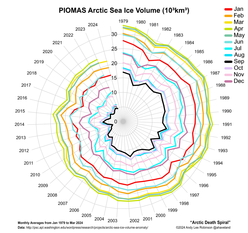
In April 2014, Arctic sea ice reached its annual maximum volume. It was the second lowest on record, according to calculations by the Pan-Arctic Ice Ocean Modeling and Assimilation System (PIOMAS) at the Polar Science Center. The ice volume in March 2014 also was the second lowest on record, as discussed in an earlier post. The fall in volume over the years is illustrated in the graph below, by Wipneus.
Another way of depicting the continuing fall in sea ice volume is the Arctic Death Spiral below, by Andy Lee Robinson.

The graph below, from the Danish Metereological Institute, shows mean temperatures that have been much higher than they used to be at higher latitudes. Mean 2 m temperatures for the region north of the 80th northern parallel as a function of the day of year are shown (red line), against the 1958 - 2002 mean (green line).


High levels of methane over the Arctic will have contributed to these high temperatures. Furthermore, the Jet Stream is changing as the difference in temperature between the Arctic and the equator decreases, causing more extreme weather events such as heatwaves and storms that could speed up the demise of snow and ice cover in the Arctic.

The graph below, by the Japan Aerospace Exploration Agency, shows that Arctic sea ice extent was 12,469,546 km² on May 8, 2014.

In addition, an El Niño event could cause even more ferocious heatwaves and storms to hit the Arctic. The image below, from IRI at Columbia University, shows that the chance of an El Niño event developing in the course of 2014 is close to 80%.


The outlook for the sea ice remains bleak and the possibility that a total collapse could occur in September calls for comprehensive and effective action, as discussed at the climate plan blog.


Wednesday 12 March 2014

Has the descent begun?

On March 9, 2014, Arctic sea ice area was at a record low for the time of the year, at only 12.88731 square kilometers.


Sea ice extent shows a similar descent, as illustrated by the NSIDC image below.

NSIDC update: The image below shows that Arctic sea ice extent was 14.583 square kilometers on March 11, 2014 (light green line), a record low for this time of the year and smaller than it was in 2006 (magenta line) and 2011 (orange line) at this time of the year.


The situation is dire, given that methane concentrations have risen strongly following an earthquake that hit the Gakkel Ridge on March 6, 2014, as illustrated by the image below.

[ click on image to enlarge ]
Huge amounts of methane have been released from the seafloor of the Arctic Ocean over the past half year, and the resulting high methane concentrations over the Arctic will contribute to local temperature rises.

The image below shows that sea surface temperatures are anomalously high in the Arctic Ocean and off the east coast of North America, from where warm water is carried by the Gulf Stream into the Arctic Ocean.


The prospect of an El Niño event makes the situation even more dire. NOAA recently issued an El Niño Watch. This follows a conclusion by an international research team that found a 75% likelyhood of an El Niño event in late 2014.

The consequences of sea ice collapse would be devastating, as all the heat that previously went into transforming ice into water will be asbsorbed by even darker water, from where less sunlight will be reflected back into space. The danger is that further warming of the Arctic Ocean will trigger massive methane releases is unacceptable and calls for comprehensive and effective action as discussed at the Climate Plan blog.


Related

- M4.5 Earthquake hits Gakkel Ridge
http://arctic-news.blogspot.com/2014/03/m45-earthquake-hits-gakkel-ridge.html

- Climate Plan blog
http://climateplan.blogspot.com


Monday 10 March 2014

M4.5 Earthquake hits Gakkel Ridge


The above image shows recent large methane release over the Gakkel Ridge, the faultline that crosses the Arctic Ocean between the northern tip of Greenland and the Laptev Sea (red line on map). Methane readings were as high as 2395 ppb at 586 mb, an altitude that often shows high methane readings originating from the Arctic Ocean.

An earthquake with a magnitude of 4.5 hit the Gakkel Ridge at a depth of 2 km on March 6, 2014, at 11:17.17.0 UTC. The location is shown on the map below.

[ click on image to enlarge ]
The image below shows more recent methane readings, around March 8, 2014.


The image below is a Naval Research Laboratory forecast of sea ice thickness for March 8, 2014, run on March 3, 2014.


Meanwhile, the sea ice is close to record lows (for the time of the year), as illustrated by the images below. The image directly below shows sea ice area.


The image below shows sea ice extent.


The image below, by Wipneus, shows sea ice volume.
The image below, by Andy Lee Robinson, offers a different way of looking at sea ice volume, the Arctic Death Spiral.